Mit dem Fahrrad - Gravel

Mit dem Fahrrad - MTB

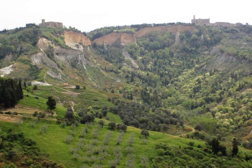
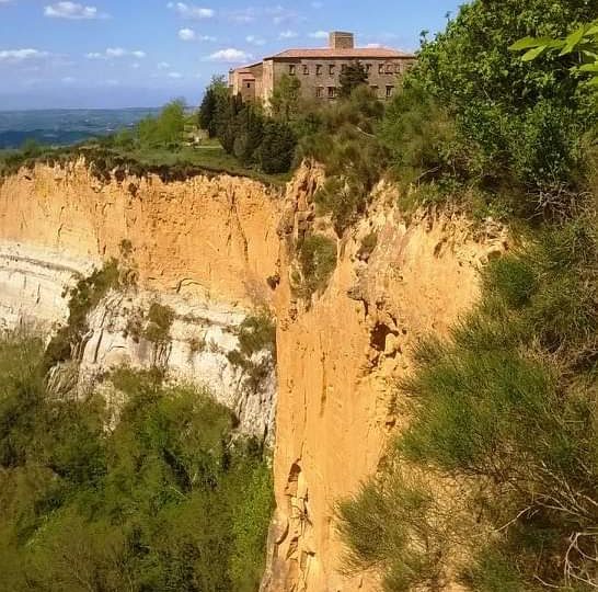
Volterra Klippen und Schluchten

Die Sonderziele sind nur im außerstädtischen Bereich beschrieben

This is a scenic ring-route with no particular technical difficulties. The itinerary starts right near the edge of the Balze chasm and is designed to allow people to discover these weird, sharp-looking shapes created by erosion: the Balze and the Calanchi and the typical agriculture and pastoral farming based system of these bizarre hills. The route features long panoramic stretches over the clay hills that stretch as far as the eye can see until they reach the sea, scarred on the steep southern slopes by the sharp ridges of the Calanchi showing their naked whiteness in the sun while the softer, less steep slopes are farmed with cereals. The Balze, with their steep walls gilded by sand and sandstone, are the result of a spectacular natural phenomenon (still going on today) in which land gradually slides on the sediments left by a sea 2.5 million years ago and they are particularly stunning at sunset. The Badia, a massive Camaldolese monastery of medieval origin which looks as if it had been hanging somewhere between the earth and the sky for its 10 centuries of history proudly stands, as a monument of extraordinary importance and a place of great charm and mystery and defies the chasm of the Balze that advances inexorably. Leaving the Abbey behind you can take a detour on a dirt road to reach the small church of San Cipriano, an exceptional watching point to enjoy the Calanche which here are of notable beauty and show differences in length and height. These hills are home to the renowned PDO cheese “Pecorino delle Balze Volterrane”, typically with vegetable rennet from wild thistle which is abundant in the pastures. Once you reach the end of this dirt road also called the “Path of Balze and Calanchi” you will find some possible detours that will allow you to easily reach the environmental sculptures of the artist Mauro Staccioli, extraordinary expressions of “land art” that interpret the essence of the artist’s “places of experience” with installations that frame the poignant landscape of the crags, gullies and windswept hills dominated from above by Volterra.

Continue

Itinerary

X

Die Sonderziele sind nur im außerstädtischen Bereich beschrieben

This is a scenic ring-route with no particular technical difficulties. The itinerary starts right near the edge of the Balze chasm and is designed to allow people to discover these weird, sharp-looking shapes created by erosion: the Balze and the Calanchi and the typical agriculture and pastoral farming based system of these bizarre hills. The route features long panoramic stretches over the clay hills that stretch as far as the eye can see until they reach the sea, scarred on the steep southern slopes by the sharp ridges of the Calanchi showing their naked whiteness in the sun while the softer, less steep slopes are farmed with cereals. The Balze, with their steep walls gilded by sand and sandstone, are the result of a spectacular natural phenomenon (still going on today) in which land gradually slides on the sediments left by a sea 2.5 million years ago and they are particularly stunning at sunset. The Badia, a massive Camaldolese monastery of medieval origin which looks as if it had been hanging somewhere between the earth and the sky for its 10 centuries of history proudly stands, as a monument of extraordinary importance and a place of great charm and mystery and defies the chasm of the Balze that advances inexorably. Leaving the Abbey behind you can take a detour on a dirt road to reach the small church of San Cipriano, an exceptional watching point to enjoy the Calanche which here are of notable beauty and show differences in length and height. These hills are home to the renowned PDO cheese “Pecorino delle Balze Volterrane”, typically with vegetable rennet from wild thistle which is abundant in the pastures. Once you reach the end of this dirt road also called the “Path of Balze and Calanchi” you will find some possible detours that will allow you to easily reach the environmental sculptures of the artist Mauro Staccioli, extraordinary expressions of “land art” that interpret the essence of the artist’s “places of experience” with installations that frame the poignant landscape of the crags, gullies and windswept hills dominated from above by Volterra.

X

Hiking difficulty scale

T - Tourist

Itineraries on small roads, mule tracks or easy paths, with clearly evident routes that do not pose uncertainties or problems of orientation. They generally take place below 2000 m and usually constitute access to mountain pastures or refuges. They require some knowledge of the mountain environment and physical preparation for walking.

E - Hiking

Routes that almost always turn on paths, or on traces of passage in various terrain (pastures, debris, stony ground), usually with signs. They require a certain sense of orientation, as well as a certain experience and knowledge of the mountainous territory, walking training, as well as appropriate footwear and equipment. Normally the difference in altitude is between 500 and 1000m.

EE - Expert hikers

Routes not always marked and which require a good ability to move on various mountain terrains. They can be paths or even faint traces that wind over rough or steep terrain, with steep and slippery slopes, scree and short snowfields that can be overcome without the use of climbing equipment. They need a good mountain experience, firm footing and good physical preparation. It is also necessary to have adequate equipment and equipment, as well as a good sense of direction. Normally the difference in height is greater than 1000m.

EEA - Expert hikers with mountaineering equipment

Routes that require the use of via ferrata equipment (lanyards, harness, heat sink, helmet, etc.). They can be equipped paths or real via ferratas. It is necessary to know how to use the technical equipment safely and have a certain habit of exposure and mountaineering terrain.

MTB difficulty scale

TC - Tourist

Route on dirt roads with a compact and smooth surface, suitable for vehicles.

BC - For cyclists with good technical skills

Route on very bumpy dirt roads or on mule tracks and paths with a rather bumpy but fairly smooth surface or compact but irregular, with some natural obstacles (eg rock steps or roots).

OC - For cyclists with excellent technical skills

As above but on very bumpy and / or very irregular paths, with significant presence of obstacles.

EC - Maximum level for the cycle excursionist

Path on very irregular paths, characterized by steps and obstacles in continuous succession, which require trial-type techniques.

Menu
Share This